
🔍 Turning Sensor Data into Smart Decisions: How Beam and Vianova Transform Micromobility Analysis in Hobart
Leveraging advanced sensor technology and data visualization to enhance micromobility management and safety analysis in Tasmania's capital.

.png)
📩 Stay updated on industry trends & Vianova product updates—subscribe to our Newsletter here!
The Context
%2520copy.png)
Beam, a leading micromobility operator across APAC and the United States, has established itself as an industry pioneer in data-driven fleet management. As part of their commitment to best-in-class city partnerships, Beam provides its municipal partners with Vianova's Cityscope platform, enabling comprehensive visualization, tracking, analysis, and compliance management of their scooter operations.
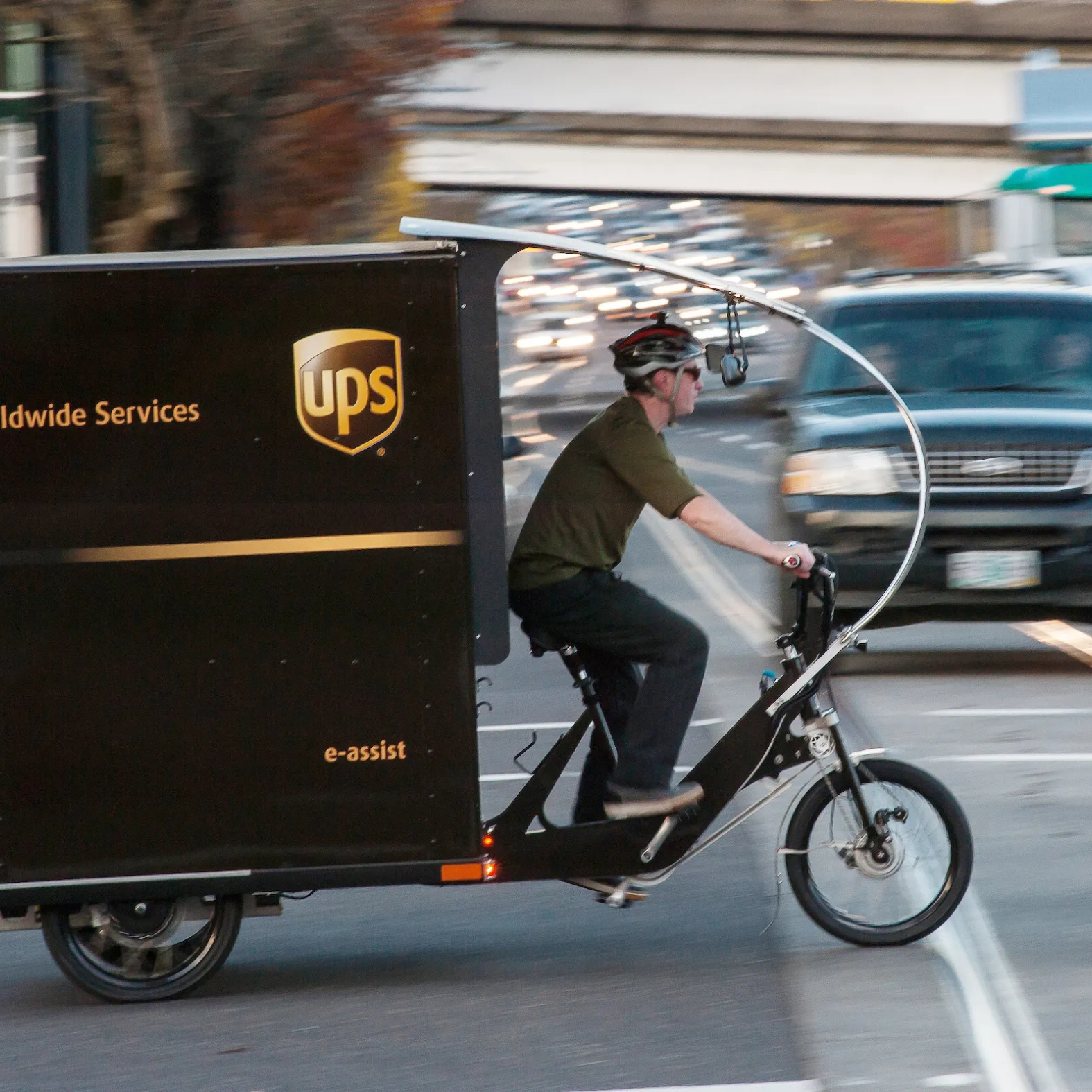
In Hobart, Tasmania’s capital city, Beam has taken this commitment to data-driven management a step further by piloting cutting-edge sensor technology. This technology not only enhances their understanding of rider behavior but also directly supports improved safety outcomes. For example, by detecting when scooters are being ridden on footpaths, Beam can automatically limit speeds in these areas, thereby reducing the risk of conflicts between scooters and pedestrians and helping the city enforce local regulations more effectively.
The Challenge
While traditional GPS-based tracking provides essential information about scooter locations and basic trip data, cities and operators increasingly need more granular insights into how and where people ride. Specifically, understanding the distinction between sidewalk and street riding patterns has become crucial for both safety management and infrastructure planning.
Beam partnered with Drover, a sensor technology company, to conduct a proof-of-concept project in Hobart using advanced camera sensors mounted on its scooters. These sensors could detect riding surfaces and influence speed controls, but the resulting raw telemetry data presented a new challenge: how to transform this valuable information into crucial insights for both Beam and city stakeholders. For Beam, such insights can inform operational decisions, such as where to place vehicles to maximize safe and legal riding. For city stakeholders, this data can drive evidence-based policy changes, support enforcement of riding rules, and be integrated with other urban mobility data systems to inform wider traffic and infrastructure planning.
The Solution
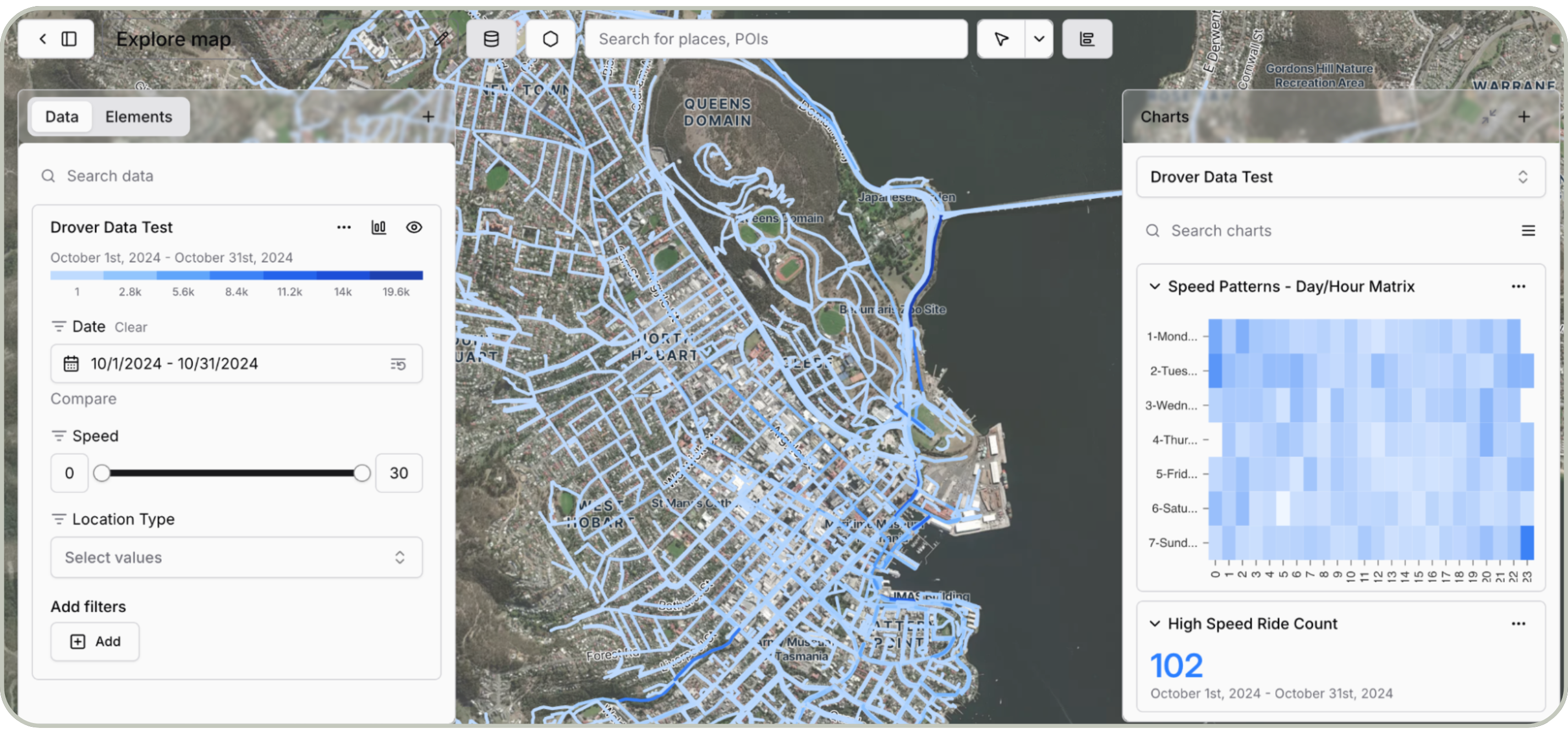
Vianova extended the capabilities of the Cityscope platform to integrate and visualize the sensor data collected from Beam's Hobart fleet.

- 🧭 Visualize precise routing patterns, including sidewalk versus street riding.
- 🚦 Analyze speed patterns across different infrastructure types.
- 🛰️ Layer multiple data sources, including bike lane information and satellite imagery.
- 📈 Generate comprehensive reports on riding behavior patterns.
Technical Implementation
The solution was seamlessly integrated into Cityscope's existing interface, adding a dedicated sensor data visualization tab alongside the standard devices and trips views.

- 🕹️ Real-time visualization of telemetry data points.
- 🗺️ Route-level analysis of riding patterns.
- ⚖️ Speed differential analysis between street and sidewalk usage.
- 🧩 Contextual overlay of infrastructure data.
Results

- 📍 Identified high-concentration areas for sidewalk riding, particularly along the Marina and Bay area.
- 🧭 Mapped correlation between infrastructure type and riding behavior.
- 🛑 Analyzed effectiveness of sensor-enabled speed reduction on sidewalks.
- 📊 Created comprehensive visualization tools for stakeholder discussions.
A particularly valuable finding was the identification of a busy coastal road where riders frequently chose to use the wider sidewalk, providing concrete data for infrastructure planning discussions.
Future Impact
This successful implementation establishes Beam and its partner cities as leaders in the next generation of micromobility management. As cities increasingly mandate sensor technology on shared mobility devices, this proof-of-concept demonstrates what is achievable with advanced data integration and collaborative innovation.

- 🛡 Enhanced safety monitoring and management.
- 🏗️ Data-driven infrastructure planning.
- 🤝 More effective operator-city collaboration.
- 🏛️ Proactive compliance with emerging regulations.
Beam expects sensor integration to become a global standard for micromobility operations, with some major manufacturers already working on integrated camera solutions. Through this project, Vianova has demonstrated its capability to transform complex sensor data into accessible and actionable insights, enabling their partners to push the boundaries of data driven decision making.
About Vianova

Vianova is the data analytics solution to operate the mobility world. Our platform harnesses the power of connected vehicles and IoT data, to provide actionable insights to plan for safer, greener, and more efficient transportation infrastructures.
From enabling regulation of shared mobility to transforming last-mile deliveries, and mapping road risk hotspots, Vianova serves 150+ cities, fleet operators, and enterprises across the globe to change the way people and goods move.
Ready to learn more? Visit our page to get in touch.
👉 Read our previous blog here!


Become part
of the movement
in the Vianova world.
Let's get in touch
Lets talk! We are excited to hear how we can help you solve your mobility challenges.